


23. Frobisher sails into the unknown
Martin Frobisher led his small fleet in search of the "Straight of Anian" only to experience a close encounter with the Inuit people of Frobisher Bay.

Why search for the Northwest Passage?
Securing funding for Frobisher’s voyage to search for a north-west passage to the Pacific Ocean was proving to be very difficult. As no concrete evidence was available that this route existed, speculators needed good reasons to back a venture that could potentially ruin them.
Current maps made available to English navigators showed the known world, but they were full of fictional places and equally fictional distances. They were as much guesswork as factual. Unknown parts of the world, such as the northern coastlines of North America, appeared as vast blank areas on these maps.
Nevertheless, English merchants began to wonder if a route to Asia existed across the top of North America. After all, they had discovered and then exploited a route across the top of Europe to Muscovy (current Murmansk and the White Sea down to Moscow).
Martin Frobisher was one of the first - if not the first - Englishmen to offer his services to find a passage to the Pacific Ocean using a north-western route. The idea circulated amongst the English merchants of London, especially the Muscovy Company, until a key member of this company Michael Lok took it up as his own project.
Securing financing for the expedition
Michael Lok was a mercer (a trader in cloth) and member of the Muscovy Company, a chartered joint-stock company. It was founded in 1551 as the Company of Merchant Adventurers to New Lands by Sebastion Cabot (John Cabot’s son) and other investors.
In 1555 Queen Mary licensed this company and gave it a new name: the Muscovy Company. The merchants of the company sent ships to Russia to trade English cloth for Russian furs and other goods. However, uncertainty in access to the Russian market made finding another reliable route to Asia an urgency.
Unaware of the challenges of the Muscovy company were having with access to markets in Russia, Martin Frobisher proposed to search for a north-west route to Cathay. Lok, a key member of the Muscovy Company learned about Frobisher’s proposal. He immediately sought out investors for this expedition.
Was Frobisher’s belief in a north-west route to the Pacific enough to convince Muscovy Company investors to contribute to this project? After many failed attempts to obtain funds, Michael Lok ended up footing the largest share of the expenses himself.
Preparing for the voyage during 1576
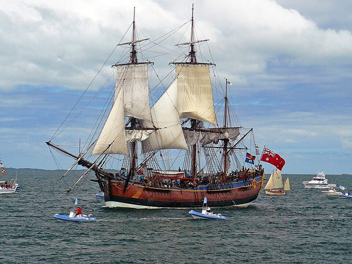
By 1576, Frobisher had his ships and crew. Lok commissioned a new ship - the Gabriel - which was a bark of about 25 to 30 tons as the lead vessel. It was accompanied by an unnamed 7-ton pinnace which was used as a fishing vessel and for explorations close to shore. Lok then bought a second bark - the Michael - which had the same tonnage as the Gabriel.
To sail and maintain the ships, Frobisher and Lok enlisted thirty-four mariners and tradesmen, all under the leadership of Martin Frobisher. This motley crew included twenty-one experienced sailors who understood the dangers and risks of sailing in the cold northern climates. These may have been veterans of the Muscovy trade or possibly fishermen sailing to the Grand Banks off Newfoundland. The tradesmen included carpenters, coopers, gunners, cooks, a smith as well as three officers. Frobisher’s number two man was the sailing master Christopher Hall. All told, the crew had the required skills, Frobisher hoped, to make the journey, make repairs to the ships enroute should it be necessary and return.
The ships would be provisioned with foodstuffs including peas which would be boiled into a mash, dried hard biscuits and dried fish. Also, each ship would have barrels of wheat and barrels of water for drink and cooking. Although beer would spoil on such a long trip, 13 tonnes of it was purchased for the crew. Additionally, Akvavit (a Scandinavian distilled spirit like whiskey) was brought on board for the officers and a large quantity of wine for the crew.
The pinnace was expected to catch fish when possible and to row ashore to refill the water barrels. They also brought small gifts which they expected to trade with any indigenous peoples they might encounter.
Frobisher informed his crew that the trip would last at least 18 months. They were to sail north to 60° then turn west towards Labrador. After heading north off the coast of Labrador beyond the 60°-degree latitude, they would then find the entrance to the fabled Straights of Anian which would take them to the Pacific. Once discovered, they would wait until the next season and return via the same route.
However, the actual sailing ended up deviating quite significantly from this plan.

Departing London on June 7, 1576
With the ships ready and sailing plans fixed, Frobisher’s fleet set sail on June 7, 1576, from the Ratcliffe Docks (today the London Docklands) and began heading towards the channel.
After only three miles, the pinnace collided with another ship and had to dock in Greenwich to make repairs to the hull. The small crew of the pinnace were not entirely responsibility for this as the Thames was an extremely chaotic road in London and this sort of thing happened often.
While getting the pinnace repaired, Queen Elizabeth who was nearby in a residence near the river was made aware that Frobisher’s ships were tied up at the docks. So, being the current monarch and license granter for this expedition, she went to a window overlooking the docks and waved to them. She then sent a message to them via footmen wishing Frobisher and his crew great success, all of which came with a fee for which Lok had to pay. It was an expensive pause.
On the 12th of June, the Gabriel, its pinnace and the Michael finally departed London and bidding farewell from Gravesend made their way towards the North Sea.
The first mate Christopher Hall began recorded the journey in his logbook. This consisted of descriptions of the various coastlines with a special note about hazards to be avoided. It was as much for use by other pilots making similar journeys as it was for use during the return voyage.
The next day on the 13th they had only made as far as the Stout estuary and had to wait for a storm to clear. On the next day, the continued north. Struggling against strong winds, they made it to the Yarmouth Roads by the 18th of June. After eight-day sailing, they reached the Shetland Islands (approx. 59° latitude north). On June 26 they entered a harbour somewhere on one of the islands to top up the ever-leaking water casks before they headed out to open ocean.
Following the 60° latitude west
Departing from the Shetlands, they sailed north into strong winds until they reached the 60° north latitude. However, once at this latitude fair sailing ended. As they pointed the ships westward, they were pummeled with gale-force winds that caused the ships to roll terribly. Yet, through it all, Hall continued his measurements to determine their location and latitude. Surprisingly, the ships kept to the 60° latitude as they crossed the open ocean towards Greenland.
It is worth noting that in the 16th century, accurately finding latitude was guesswork at the best of times although navigators were getting better at it after knowledge transfer from the Portuguese and Spanish. English pilots had discovered during their frequent trips to Muscovy that longitude, dimly understood then, narrowed as their ships sailed higher towards the Artic. Even determining latitude became challenging. If the sky was clear, using an Astrolabe and other mariner tools which depended on the North Star were sometimes unreliable. At these latitudes, the North Star was too high in the sky to be useful as a navigation aid. So, Hall could only guess and use his Astrolabe and other navigational aids to keep the ships pointed westward. Frobisher and Hall faced these challenges as the ships fought gale force winds and dark skies across the north Atlantic.
Greenland spotted July 11, 1576
Yet, Hall was successful. By the 11th of July, almost one month after departing London, they spotted land to the starboard side (port: left side of the ship, starboard: right side). This meant they were passing below some yet unknown land. Frobisher and Hall thought it was “the great Iland of Friesland”. However, this coastline was the southern tip of Greenland.
Surprisingly, they had achieved their goal of heading west along the 60° parallel. But what he they saw astonished them. Like the Norwegian coastline, the saw “high ragged Roks all along the coast”.

Loss of the pinnace in Davis Straight
Without finding a place to anchor, they continued their journey around the southern tip of Greenland. They then followed the coastline until it began its northern march as far as the eyes could see. After they had found the 60° latitude again, they pointed their ships westward across a vast body of water which in later times would be called Davis Straight. This was, and is, a dangerous straight between Greenland and Labrador in the south and Greenland and Baffin Island in the north.
As they headed across the Straight, another violent storm arose. This caused the ships to separate, and Frobisher’s Gabriel lost sight of the Michael, while the pinnace raced up and down the mountainous waves. As the giant waves pounded the ships, water poured onto the decks causing them to roll over to an alarming 45°-degree angle. As the ships began their roll to the other side, the bark’s low forecastles allowed the water to gush out ready for the next accumulation of ocean waters.
Sadly, the pinnace was not so fortunate. Its four unlucky mariners managed as best as they could under the circumstances but the boat was eventually overwhelmed by the giant waves. It was swamped and went down with loss of all onboard. Frobisher was now down to less than thirty crewmembers and had lost a ship capable of moving in close to shore and for fishing.
After four days of terrifying sailing, the Gabriel and Michael spotted land some distance away. Not sure of what land they were seeing, they attempted to move towards it but they could not find anywhere to get close to shore. Attempts at sounding depths showed extremely deep water. So Frobisher turned the ships northward hoping to find the entrance to the Straights of Anian, which they believed was the entrance to the Northwest Passage.
The Michael returns to London
As they sailed on, they began to encounter massive icebergs that caused the ships to separate.
At this point, the Michael was some way off and out of sight of the Gabriel. The crew of the Michael uncertain of the fate of Frobisher’s ship decided to turn back towards Greenland and sail back to England.
At the same time, Frobisher was inching his way through the icebergs and was unaware of this decision. As the captain of the Michael feared the loss of Gabriel, so too did Frobisher fear the loss of Michael. Frobisher then determined to sail on and leave the fate of his crew on the Michael to God.
After gingerly sailing through the ice fields, on the 26th of July they spotted “an icebound land” to the west. Taking latitude, Hall found that they were at 62° - 2’ N. Frobisher and Hall assumed the land they saw was Labrador, but the Gabrield was several hundred miles to the north of the continental land mass. What they saw was an island today is known as Resolution Island, but they had mistaken it for a peninsula.

Later, in 1578 the Earl of Warwick described the terrain that Frobisher saw.
The Counties….lye very highe with roughe stonie mounaines, and great quantities of snow thereon. There is very little plaine grounde, and no grasse, except a little, which is much like vunto mosse that growethe on soft ground, such as we get Turfes in. There is no wood at all. To be briefe, there is notting fitte, or profitable for the vse of main…there is great likelyhood of Earthquakes, or thunder: for that there are huge and monterous mounteines, whose greatest substance are stones,…1
Resolution and Baffin Islands
Two days later on the 28th of July, Frobisher attempted to reach this unknown shore. However, as they sailed towards it, the strong Labrador current caused the ship to move south instead of west. To make matters worse, they encountered ice fields which could tear into the wooden hulls which they had to avoid.
Finally, they resolved to head north and then out to sea in the hope of finding another landmass with suitable landing areas. As they followed the coastline Hall continued to take soundings but could not find bottom. The continental shelf of Baffin Island drops precipitously almost immediately beyond the shoreline. This made landing impossible.
Soon the Gabriel was sailing across open waters that were about 60 nautical miles across. Having failed to make any landfall on what was to become Lok Island, Frobisher then pointed the ship northward hoping to find another suitable location. They were now out of sight of land.
Hall’s Island and a black rock found
Soon Hall spotted a small island in the distance. As they got close, they found a place suitable for landing. Frobisher had the landing craft launched and sent Hall and a few mariners to inspect the island. The landing party climbed up to the highest point to get an overview of where they were. Looking down to the sea they could see the Gabriel below them; looking east they could see the Davis Straight; most importantly, they could see the steep cliffs and mountains in the west stretching north as far as the eye could see. This was Baffin Island.
Seeing the tide coming in, they quickly ran down the hill back to the boat for fear the incoming tide would prevent them from departing. As they were heading back, a sailor by the name of Robert Garrard, found a black rock about the size of a loaf of bread. Wondering what it was, he grabbed it and took it with him to the boat. This seemingly insignificant act would soon lead to all sorts of trouble for Frobisher and Lok, which we will discuss in due time.
The island became known as Halls Island but it was later called Little Halls Island when the much larger island just north of it was found. That island would become Halls Island.
Entering Frobisher Bay
Back in the Gabriel, the mariners hauled the landing craft out of the water and stored it on board on the ship. Frobisher decided to sail to the open water they had previously crossed. After passing what became known as Lok Island, the entered what they believed to be the Straight of Anian, unaware that it was a bay.

Before they could make any progress up the “Straight”, however, Frobisher needed to find a safe place to make repairs to the hull. They found a sound (most likely Waddell’s Bay) where they could anchor and begin repairs.
Afterwards, sailing north-west hugging the western shoreline, the weather became calm but very cold. This caused a thick layer of ice to build up on the masts, decks, ropes and anything exposed to the icy temperatures. It’s hard to imagine how the mariners were coping.
First contact with the Inuit people
In a day or two, they spotted an island they named Thomas Williams Island (today Culbertson Island). By August 18th, they reached Burcher’s Island, named after a crew member who first sighted it.
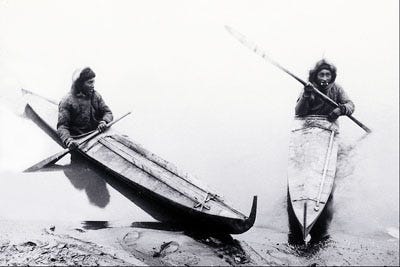
Frobisher, Hall and several mariners decided to row to the island. They climbed to the highest point of the island. They spotted what they thought was some strange creature floating along the top of the water. After watching it for some time, they realized it was seven or eight small boats gliding across the tops of the waves each being rowed by a single rower. The boats were covered and in of the middle of the boat sat a man holding an oar.
Frobisher and Hall immediately dashed to their boat and got on board the Gabriel. They then sent their small boat after them in the hope of meeting them and getting them on board the Gabriel.
The Inuit stopped to observe these strange people. They didn’t seem afraid of the Englishmen but appeared to wonder who these people were with their strange boats. We know today they are the Inuit and their boats are called “Kayaks”.
One Inuit rowed up towards the Gabriel and followed it as it anchored off Burcher’s Island.
Frobisher sent Hall alone to the island to meet these indigenous people. Frobisher must have felt they were no threat and sending one man alone would not be threatening. Hall approached them in peace. Several were convinced to come on board the Bark to share a meal with Frobisher. They agreed and climbed on board. After eyeing each other for some time, Frobisher offered some of their food, which wasn’t quite to their liking. The meeting must have been momentous. Two peoples who had never seen each other before had shared a meal, not that the Inuit liked it. But at least they were polite about it.
Hall wrote some words in his notebook about these indigenous peoples:
They bee like to Tartars, with long blacke haire, broad faces, and flatte noses, and tawnie in colour, wearing Seal skinnes, and so doe the women not differing in the fashion, but the women are karked in the face with blewe streekes downe the cheeks, and round about the eyes.2
Hall asked them to teach him a few of their words for things, such as fingers, hands, legs, and so on. Frobisher then gave some small gifts, which he assumed was a sign of friendship. However, to the Inuit people such gifts meant little. It didn’t mean any binding friendship or even a token of trust. It was simply something given to them, as interesting as the “trinkets” were. And they were not considered by the Inuit anything of value.
Trust evaporates between Frobisher and Inuits
Frobisher, Hall and a few mariners went ashore to visit the Inuit village, which they had seen from the ship. After speaking with the villagers, an Inuit man was invited to go on board the Gabriel to be a guide through the “Straight”. After getting on board, the man indicated that he needed to return to his home to prepare for the journey. Five mariners took him back in the small boat. Frobisher had commanded them to take him to a place some distance from the village. However, the mariners didn’t obey their commander but took the Inuit directly to their village. They didn’t return to the Gabriel. After waiting some time, Frobisher feared the worse. They were never seen again.
After several days of searching for them, they were presumed dead. Even the boat was not found. Their disobedience had cost them their lives. Frobisher lost five valuable men as well as the landing boat. It was a terrible turn of events.
Capture of an Inuit man and his Kayak
It was now nearing the end of August. The Gabriel continued on its journey up the “Straight”, On August 22, several Inuit in their Kayaks approached the Gabriel but prudently kept their distance. Frobisher enticed one of them to row towards the ship by tossing trinkets into the water just ahead of the Kayak. Frobisher kept doing this until the man was right at the side of the boat. Frobisher dangled a little bell just out of reach of the Inuit and as the Inuit man reached up to grasp it, Frobisher took hold of his arm and pulled both him and his Kayak to which he was still attached into the ship.
Frobisher had his hostage. And he planned on bringing him back with him to England.

Frobisher decides to return to England
Frobisher put the Inuit man down below deck in the ship’s hold. As they were securing the hostage, almost a foot of snow came down within a very short time. This caused Frobisher to consider the situation they were in. Summer was nearing the end. The weather would not improve any time soon. They were unsure where this “Straight” led. With the (presumed) loss of the Michael, the Pinnace with its four men on board and now the landing boat with all five men killed or abducted by the Inuit, Frobisher really couldn’t continue on.
So, on the 23rd of August, Frobisher uncharacteristically “assembled his men upon the deck” of the Gabriel to ask them if they should continue or return to England. They needed to decide quickly.
And they all agreed that, consydering ther evill & weak state by the los of their Bote, & and five of their best men & the weakness & litle hability of the rest of the men that were left in the Ship, being but xiij [13] men & boyes, so tryed & sick w(ith the) laboure of their hard voyage, passed as they were neither hable weel to procede in any long voyage toward the Tyme of winter nor yet of (remaining more than that time) already passed than to procede (more) with great danger of the vtter (destruction of the enter)prise for ever after yf they should (not now pass) away.3
The decision was made. They would retrace their steps and sail back to England. Their only hope was that they would make it back alive and not suffer the fate of the Michael.
They had sailed approximately 130 miles (almost 60 leagues) into the “Straight” , almost 3/4 the length of the bay. This was the furthest point north Frobisher would make on all of his journeys. However, he was never to learn that it was a bay that he had entered. He insisted it be called Frobisher Straight, though Hall had a suspicion that it was just a large inlet.
Frobisher commanded the crew to sail south and commended the five lost mariners to their fate. They inched their way out of Frobisher Straight, passed Lok Island and then across the Davis Straight towards Greenland. By the 1st of September they came in sight of Greenland. As before, they attempted to find safe anchorage, but were unable to make a landing due to ice and thick fog. Catching the winds, they made good sailing across the Atlantic towards Great Britain. During this time, one of his crew fell overboard but amazingly Frobisher once again used his powerful build to heave the man into the ship.
By September 25th they were off Orkney islands (part of Scotland) and by October 1st they reached the port of Harwich by the river Stout estuary on the eastern coast of England. From this port they sent a message to London to inform Michael Lok that they were nearing the Thames.
Lok could not believe what he heard. The Michael arrived some time previously with the message that the Gabriel was lost at sea. Meanwhile, Frobisher believed the Michael was lost at sea. It is hard to comprehend the surprise Lok must have felt knowing both were to be back in port shortly.
Reaching London
On October 9th, 1576, Frobisher on the Gabriel with his reduced crew and the Inuit hostage entered the port of London with a large metal globe attached to the bowsprit of the Gabriel. Lok had purchased it and had it installed while the Gabriel was some way downriver from London.
When they landed, Michael Lok was there to greet them. As soon as the ship was tied up, he got on board to see the Inuit.
Like Hall, Lok compared this Artic native to the Tartars. He had short legs but was well built. He seemed well nourished but unhappy, understandably. Lok also inspected the Kayak, a boat which he had never been seen before.
Sadly, in a few short weeks, the Inuit would die of a sickness. As for the Kayak, no record exists of its survival.
What had Frobisher achieved?
Frobisher had sailed further north than any explorer to date. He added a new territory to maps of the world. However, other than he accomplished ittle of value for England. The Northwest Passage remained a distant dream.
In one important respect, Frobisher had proved his skills at commanding ships in the most dangerous of conditions. Queen Elizabeth took notice of this achievement. Later, when England went to war with Spain, The Queen would promote him to commander in the Royal Navy. But that was in the future.
For now, a problem lay stored in a barrel in the hold. It was the loaf-sized black rock grabbed on a whim by one of Frobisher’s men during their visit to Hall’s Island. The irony of this event is that the man who picked up this ore never made it back to England, He was one of those men abducted by the inuit. He will never know the trouble that rock was about to make for Michael Lok.
And this we will take up in our next installment of the life of Martin Frobisher.
Further reading
McDermott, James. Martin Frobisher: Elizabethan Privateer. Yale University Press, 2001.
McDermott, Martin Frobisher: Elizabethan Privateer, 138
McDermott, Martin Frobisher: Elizabethan Privateer, 144.
McDermott, Martin Frobisher: Elizabethan Privateer, 147.