


21. Controlling the choke point: Spain's dominance of the Caribbean
From today's perspective, it's hard to see the power Spain held over the Americas in the 1500s. It would be like America preventing any other nation from travelling to the moon.

Authors note: Recently I lost the use of my laptop so with that issue finally resolved, this latest article arrives slightly later than I had scheduled.
The great obsession: finding a route to Asia
As European explorers gradually came to the realization that the lands first encountered by Christopher Columbus in 1492 and then by subsequent explorers were in fact not Asia but a great unknown land mass, searching for a passage through it (or around it) became an obsession.
In 1519, Ferdinand Magellan, a Portuguese explorer sailing for Spain, sailed across the Atlantic and followed the coast of South America to the southern tip of the continent. He then threaded his fleet through a complex set of islands now called the Magellan Straight to reach the Pacific Ocean. After crossing the Pacific, then known as the South Sea, his expedition finally reached Asia. After getting himself killed in the Phillipines, Magellan’s remaining ships under new leadership continued on and managed to circumnavigate the globe - the first ever to do so - in September 1522. This incredibe feat confirmed a route to Asia was possible but also confirmed travelling around the southern tip of the Americas was a terrible way to get to there. A better way was needed.

It’s not like a way to the Pacific Ocean was unknown in 1521. A few years earlier in 1513 the Spanish conquistador Vasco Núñez de Balboa heard about “another sea” where people living in coastal villages possessed so much gold it was like lights in a dark jungle.
So, with avarice engaged, Balboa set out on September 1, 1513 to find this gold. Starting from present day Columbia, he travelled up the western shoreline of the Caribbean and reached a native settlement within what would today be called Panama. This village (now called Carreto) was led by a local chieftain called Careta who after Balboa defeated his tribe in battle decided to convert to Christianity and became an ally of Balboa. This chieftain and some of his people (about 1000 men) joined the expedition. They set off westward through the Darién region, a hot, humid area of rainforests, swamps and low cloud covered mountain ranges.
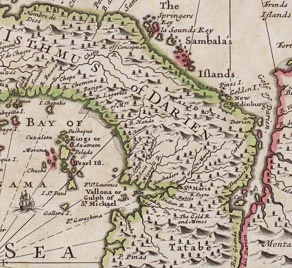
Not long after departing, Balboa and his group of Spanish and native men and a pack of dogs encountered rivals of the chieftain Careta. The Spanish-led expedition made quick work of these rival chieftains, thus opening up a way to pass on westward towards their goal. As they continued, the coastal plains ended and the terrain became much more challenging as they climbed the mountains of the Darién. Along the way they dealt with the typical rainforst creatures both small and great that made the journey in those parts miserable.
By September 25th, 1513, they had reached a suitable vantage point on one of the mountains they were able to see the Gulf of Darién from which they came. Turning to the west, they peered into the distance and spotted for the first time the vast expanse of the Pacific Ocean.
Having seen their goal, they quicky descended through the mountains and after another scurmish with native tribes managed to reach a salt-water bay which Balboa named San Miguel. After reaching the coast of this newly discovered ocean, Balboa walked into the salt water and claimed it for Spain. The date was September 29th 1513. He called this ocean the “South Sea” because he walked southward from the eastern shore to reach this point. In the Age of Exploration, the need for greatness often overshot reason. From today’s vantage point, it is hard to see how claiming an entire Ocean or Sea as belonging to one country makes any sense, but in 1500s Spanish mentality allowed for such grandious thinking.
Although they had travelled a mere 68 miles (110 km), it had been extremely challenging: they fought against hostile tribes, traversed thick rainforests, endured poisonous reptiles and swarms of biting insects, marched through the low hills of the Darién and faced disease and exhaustion. But the Pacific Ocean had been discovered. And the only known route had been claimed for Spain.

A southern route to the Pacific was in the bag. A central route to the Pacific was in the bag. This left a northern route outside the known experiences of European explorers. This job would be left to the English and French, and as routes go, this one would evade discovery for centuries.
Yet, the Ottomans still blocked the eastern route to Asia through the Mediterranean Sea. For some time, the long and dangerous route around the African Continent was known and frequently used but primarily by the Portuguese. This southern passage, discovered by the Portuguese explorer Vasco de Gama, followed the African coastline to the Cape of Good Hope and then continued into the Indian Ocean.1 It wasn’t ideal, as if any route to Asia was easy. Thia route went through some extremely hostile areas where pirates and coastal Marauders frequently targeted European shipping.
Consequently, for the ambitious northern kingdoms of England and France, this route around Africa was out of the question, although they frequently sent ships to the western coast of Africa for trade. So, the only reasonable choice was to find a western route but Spain and Portugal were out of the blocks first and they fiercely protected their territories. Any other kingdom was playing catch-up.
To get to the heart of the matter, we need to take a look at how it all started. And to do this we need to discuss Christopher Columbus.
A short primer on Columbus, because of course
Columbus Day is celebrated in the United States. It is an odd holiday considering Christopher Columbus never once came ashore on what would become that country. It makes as much sense as Canada having a holiday called Vasgo de Gama Day. As readers of Beyond Brant and Brock know, the title of discoverers of what would become Canada began with the Venetian John Cabot sailing under the banner of Henry VII of the Kingdom of England and later the Frenchman Jacques Cartier sailing under the banner of Francis I of the Kingdom of France. Of course, long before Cabot and Cartier, the Norsemen (Vikings) were known to have built a settlement on a windswept corner of Vineland (Newfoundland).

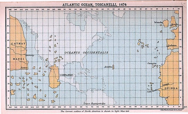
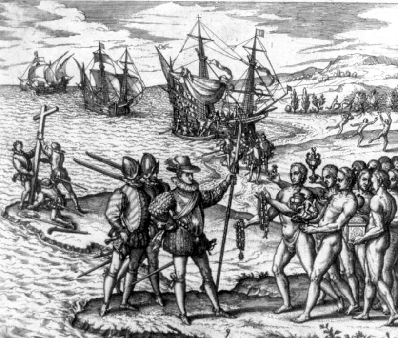
Chrisopher Columbus (1451 - 1506) was an Italian explorer from the Republic of Genoa sailing under the Spanish flag to find a westward route to Asia (in reality he wanted to find India). On his first voyage westard across the Atlantic Ocean he unexpectedly discovered a set of islands. He found them after noting an increase in the number of birds in the air, a sign of land nearby, and followed them to learn where they were landing. What he found stunned the Genoan explorer and his crew.
He didn’t expect to find land so soon after departing Cadiz, Spain - in fact he found an island of the Bahamas . Believing this was part of the eastern edge of India, he immediately declared it India and claimed it for Spain. This erroneous belief was based on a map prepared by the Italian Paolo Toscannelli who sent a copy of it to Christopher Columbus. This led the Genoese explorer to believe Asia was significantly closer to Europe than it was (or perhaps that he believed he had sailed further than he actually had). At any rate, when Columbus spotted land, he naturally assumed it was some unknown islands close to India.
Soon after setting foot on the island he enountered a group of native people whom he, again, assumed they were Indians - or Los Indios. Typical of the age, he was completely unaware of who and what exactly was an Indian but the people he encountered were neither Indian or Asian. They were Taino, part of a large group of peoples inhabiting the islands from the Bahamas south towards the Leeward Islands.
After meeting them, his eyes fixed on the only thing he seemed to care about these people; these seemingly savage people all wore gold jewelry and ornamentation. as was their normal custom. Columbus immediately wanted to know where their got the gold to make their jewlery. Innocently, the Tainos told them they obtained it from places far to the south. This gave Columbus all he needed to know. The land was full of valuable riches ready for the taking.
Columbus made three more voyages to the newly discovered islands and claimed each island and landfall for Spain. Some islands he landed on were of significant size, such as Hispaniola, Cuba, Jamacia and Santo Domingo, to name a few. He eventually landed in Central America and parts of South America, all of which he claimed for Spain.
On one of his voyages, Columbus encountered the Caribs who were not related to the Taino peoples he first met. The Caribs were a warlike people who dwelt on the islands of the Lesser Antilles such as Guadeloupe and Dominica. Despite their smaller numbers compared to the Taino, their name became applied to the entire region and the inner sea became known as the Caribbean.
What started bad became worse
What started as a stunning discovery by Columbus in 1492 developed into the usual state of things for native peoples invaded by Europeans colonizers the 16th Century. Any land discovered was claimed for the Spain. To put it in a more meaningful way, these lands were basically stolen without the approval or agreement of the native peoples; no treaties were made between the parties. They were simply claimed for the Spanish monarchs.
The Spanish explorers had two goals in the Caribbean: find locations ideal for settlement; find commodities and minerals to be shipped back to Spain. In each of the islands they identified area for settlement, usually places with good harbours and near arable land for growing crops.
Items to be shipped overseas were brought to these local ports. Local sailing vessels would then bring them to specific ports where the goods would be loaded onto large vessels to make the journey back to Spain in convoys to protect the fleet from piracy.
Famously, many of these ships were full of gold (usually stamped into coins), silver and other valuable minerals collected from far flung areas of Spain’s new territories. But precious metals were not the only items found in the freighter’s holds. Newly discovered fruits and vegetables such as potatoes, tomatoes and maise ended up in the holds. Animals such as Guinea pigs were loaded onto the ships; it turned out Guinea pigs were useful sources of meat on long voyages - these animals could be easily stored alive on board and cooked as required.
They also found plenty of citrus fruits which could be shipped back (dryed I assume). These fruits provided a good source of vitamin C which spared not only settlers but also sailors from the scourge of scurvy. At the time they didn’t make the connection between the fruit and lack of scurvy but they did notice the northern nations suffered terribly from scurvy and assumed it was a personality trait of these peoples.
Spain as Superpower
Spain became the 16th Century superpower. Its vast territory stretched from the Danube and Northern Germany to the Caribbean and along the western coast of the Americas. And from the newly found territories across the Atlantic, the Spanish Empire extracted vast quantities of gold to enrich the homeland. The cathedrals, castles and ports of modern day Spain bear witness to this incredible wealth.
So much silver circulated throughout western Europe that its value plummeted and silver coins no longer held their value. It had a profound impact on European culture. It led to the absorption of Portugal into the Spanish empire. And perhaps most importantly, it led to the rise of the English and French crowns as competitors to Spanish domination of Europe.
Perhaps the best example of the power of Spain (and Portugal) during the 1500s was the Galleon. Known primarily as a warships, they were usually run as armed cargo ships. These ships would gather at specific Caribbean ports near the Atlantic, such as Santo Domingo, and await the arrival of local vessels who would transfer their commodities or ores onto the Galleons for shipment across to Spain. They also were used to bring to the Spanish colonies African slaves to work the plantations and mines.
Spanish Conquistadors and the Inquisition
But the Spanish colonies would be founded not by cheerful settlers but by conquistadors who conquered territories by force and enslaved local tribes.
The Spanish conquistadors were leaders of Spanish military units that were authorized by Spain to conquer whatever territories they found. After absorbing Puerto Rico, Hispanola, Cuba and Jamaica, the Spanish continued their westward conquests by landing along the northern coastline of South America, eventually reaching the lands of Mesoamerica from present day Mexico south to Peru.
The peoples they encountered were unlike the island tribes such as the Caribs. The Maya peoples in what is today southern Mexico were powerful, organized and ready to defend their lands. But Spanish conquistadors made short work of them and conquered their territories. Moving north into Mexico proper, the Spanish came upon the Aztecs who built large “cities” in central Mexico, with the largest being Tenochtitlan. The Spanish conquered this vast city in 1521 renaming it Mexico City. The name Mexico is derived from Nahuatl which is the “language of the Uto-Aztecan family, spoken in central and western Mexico”.2
The Inquisition was very much in effect in the 1500s. According to Papal decree, any non-Christian was subject to conversion to Christianity, first by Catholic priests and failing that, by force. As an example, the horrors inflicted upon Jews in Iberia during the time of the Inquisition caused many to convert to Christianity (who were called Conversos) while those who were unwilling to convert were rounded up and burnt at the stake. The same rules applied to the native peoples in the islands of the Carribean and the lands in Central America.
(Surprisingly, a large community of Jewish conversos found their way to Jamaica to form one of the first settlements on that island. Many took up piracy against Spanish shipping as acts of revenge for the horrors committed upon the Jews in Spain.)
But back to our story, the Spanish invaders of Aztec lands were stunned to see the vast quantities of silver and gold, especially in the Aztec city of Mexico-Tenochtitlan. Soon much of this wealth ended up in the holds of Spanish galleons to be sent back to Spain.
Sadly, these peoples of Mesoamerica and the Caribbean became afflicted with European diseases against which they had no natural immunities. What was at the time of conquest a population larger than that of Europe slowly decimated to a small percentage of the original number of peoples.
So, according to the 1500s playbook, what had started as a bad desire for stripping the riches of conquered lands ended in a catastrophy for the native populations of the newly found lands.
England and France defy Spain and Portugal
During the early part of the 16th century, sometimes known as the beginning of Age of Discovery, routes to India and Asia were not only known but they were considered highly-guarded Intellectual Property. Routes around Africa, around South America and through the Isthmus of Panama had been mapped and known throughout European capitals. However, revealing details of these routes were highly classified and kept secret - except they weren’t. Nevertheless, penalties included execution were carried out on those who offered this information to other nations.
So , by the 1530s, the known routes to the Asia were blocked by the Iberian powers. The Caribbean was off limits to English and French ships. But it didn’t stop French and English sailors from probing their defenses and attacking Spanish or Portuguese settlements when possible. Caribbean islands were natural targets and pirates found them easy picking for looting.
Still, But a better solution needed to be found.
By 1534, Jacques Cartier offered a vague idea of a large inland river that might prove fruitful. (See my articles on Jacques Cartier). Likewise the English sought a northern route to Asia. The Portuguese, as befitting their befuddled belief that territories in eastern Americas belonged to them by divine right, sent a few expeditions north to claim lands for the themselves. The upshot of their efforts resulted in the naming of northern lands Labrador. That name has stuck, at least for a small portion of northeastern lands east of Quebec.
This led to the search for a northwest passage to Asia. Essentially, this was a passage across the top of the American continent. Surely, the English must have thought, there must be a passage across the northern coastline of this great landmass. It was just a matter of sailing north and then going west to discover it. The Vikings had been the first to sail north along the western side of Greenland and the Portuguese added some geographic knowledge during their voyages. It became known that the lands were inhabited with the Innu along the Labrador coast and Inuit peoples further north and on Greenland3 As a result, this part of the northwest passage was well known to the English sailing community in London and Bristol. Fishermen and whalers had long made the arduous journey north to Iceland and Greenland in search of cod and whales.
Going beyond the furthest known point in the 1550s, today’s Ellesmere Island, was a open question and to the English, a challenge worth undertaking.

To start the ball rolling, figuratively speaking, the English sent out at least three expeditions under the leadership Martin Frobisher and it is these voyages which we take up in the next article.
This is not to say Innuit and other native tribes in the North had already learned how to navigate it by then. But that is unknown to history.
Refer to “Nahuatl language” in Britannica.com.
Some historians have suggested Dorset peoples may have mingled with Vikings to become the peoples of today’s Greenland, however genetic studies have proven this to be wrong.